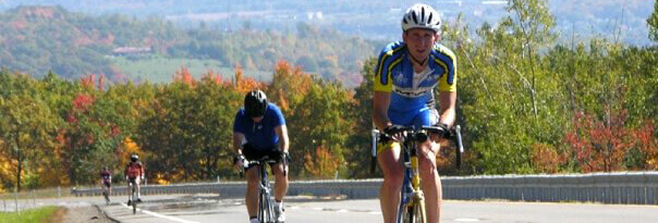
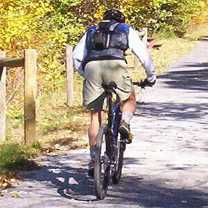


Cycle. Snowshoe. Cross-Country Ski.
There are over 400 miles of trails in Clearfield County to explore at your leisure. Often you will go for miles without seeing another person. This solitude is good for mind and body in many ways. Most of the trails listed here are versatile and allow for all-season sports, but some are just for the cycling enthusiasts.
Always plan ahead and make safety your first priority. A lot of trails are located in areas without cell phone reception or close neighbors. Check cellphone coverage at http://opensignal.com/network-coverage-maps before venturing on your journey.
Please share your experiences and photos on our website or social media pages. We love hearing from our visitors and are always looking to make your experience better.
Beaver Dam Trail
2.3 miles, blue blazes, easiest hiking. Located at Parker Dam State Park. This trail along Mud Run traverses good beaver habitat. Be on the lookout for signs of this amazing creature, like cuttings, tracks, lodges and dams.
Beaver Meadow Trail
1.5 mi. - This asphalt trail was developed as a Safe Routes to School project, the Beaver Meadow Trail runs for 1.5 miles between Liberty Boulevard and Schaffer Road (SR 4017). The paved trail offers a pleasant stroll or short bicycle ride along Sandy Lick Creek and offers a dog park for travel with your best friend.
CCC Trail
1.6 miles, blue blazes, easiest hiking. Located in Parker Dam State Park. This trail is a walk down memory lane to the days of the Civilian Conservation Corps (CCC). This was the road used daily for travel between the residential CCC camp (now the Organized Group Tenting Area) and the work site at the dam. Now the road serves as a trail, making its way through pleasant pine plantations, traversing from Tyler Road to a point on Mud Run Road. A connector trail leads to Laurel Run Trail; this is a hiking only trail, not suitable for skiing or bicycling.
Meadow Street to Carbon Mine Road
4 mi. - (Rails to Trails) - This is a nice flat stretch of the Clearfield to Grampian Rail Trail. Most of this stretch runs along the West Branch Susquehanna River, and there are a few places for you to stop and enjoy a picnic or just take a rest and see, smell and listen.
Curwensville Lake West Trails
8.6 mi. - There are 12 named and color-coded trails on the west side of Lake Drive on the Curwensville Lake Recreation Area and surrounding game land property. These trails range in difficulty and length. If you’re a hardcore outdoorsman, plan on camping at a rustic tent site, electric site or in one of the primitive cabins.
Curwensville Lake East Trails
6.6 mi. - There are 9 named and color-coded trails on the east side of Lake Drive on the Curwensville Lake Recreation Area and surrounding game land property. These trails range in difficulty and length. If you’re a hardcore outdoorsman, plan on camping at a rustic tent site, electric site or in one of the primitive cabins.
Rockton Mountain Trails
11.1 mi. - A cross-country ski trail system in winter, the Rockton Mountaintrail system is a superb mountain bike trail network. Not only are riders having a blast on the many trails, but they are helping the state forest service maintain them. Riders keep the trails clear and the grasses down. This is one of a few places where the state is catching on to the benefits of mountain bikers. Rockton Mountain is relatively flat and broad, but has its fill of rock along the trail. Highlights: technical ridge-top ride, great wildlife viewing, entire route blazed for your route-finding convenience. Tread: a rugged mix of rocky and rooted single track, rough old woods roads, double track and a small section of forest road.
Moose Creek/Greenwood
25 mi. - This is a mixture of dirt, gravel and pavement. Starting in Curwensville, you can either take state route 879 toward Clearfield or you can hop on Rails to Trails. Take SR 153 to the base of Rockton Mountain, and turn right onto Old Penfield Road. Go about 5 miles (mostly uphill), and you will come to SR 153. Cross SR 153, and continue onto Upper Dubec Road for about 1.5 miles. Next, turn right onto U.S. Route 322 for about a mile, and then left onto Greenwood Road for 9 miles of mostly flat and downhill riding.
Race Course
22 mi. - This is the route of a local race that has been put on here since 2006. It is a challenging and fast loop that starts in Clearfield and goes up Park Avenue, which is a 2-mile climb and heads toward Glen Richey and Olanta. If you want to switch things up, you can make a left hand turn onto Turkey Hill just outside Glen Richey. This is one of the most challenging 1.25-mile climbs in the county. The ride then turns onto SR 453 and heads back toward Curwensville. There is another short climb followed by a 2-mile, white knuckle downhill where 50+ mph can be had. The final stretch is a 7-mile flat section following the West Branch Susquehanna River back to Clearfield.
Lumber City
22 mi. - This is one of the flatter routes in the county, but there are many options off of this route that turn uphill in a hurry and challenge even the fittest cyclist. Start in Curwensville and take SR 879 West toward Grampian and Bells Landing. At mile 10 you will want to turn left onto SR 969 and head back to Curwensville. This is about 12 miles of mostly flat highway with a couple small rollers. This ride finishes with a great view of Curwensville Dam on your right. This course is ideal for cyclists who want to do a personal time trial to measure their fitness on a weekly or monthly basis.
Rockton Mountain Ride
10 mi. - In early October for the last 10+ years, there has been a 5-mile uphill time trial on this stretch of highway to see who is king and queen of the mountain. This is not the steepest hill in the county, but it is the most challenging. It is 5 miles long and you will no doubt battle the wind and yourself on your way to the top. Cars will pass you along the way and they will look like ants when they get to the top of the mountain and you will still have a long way to go. You will indeed have to dig deep within yourself on this one. Your reward will be a long 5-mile descent back down the mountain.
Skunk Trail
1.4 miles, blue blazes, easiest hiking. Located at Parker Dam State Park. This trail winds through hardwood trees. It connects Souders Trail with Mud Run Road.
Souders Trail
0.75 mile, yellow blazes, easiest hiking. Located at Parker Dam State Park. This scenic loop trail features Laurel Run, lush meadows and large hardwood and evergreen trees. Only a part of Souders Trail is multiple use (cross-country ski, bicycling); the biggest part of the Souders look is hiking only.
Clearfield to Grampian Rail Trail
11 mi. - There are several places to access this spot in Clearfield, Curwensville and Grampian. The Clearfield to Curwensville stretch is relatively flat and runs along the West Branch Susquehanna River. The Curwensville to Grampian section has more of a grade and is decorated with nature’s scenery.
Houtzdale Line Trail
11 mi. The trail is lined with hedgerows of multiflora and other deciduous shrubs. The entire length of the Houtzdale Line Trail is open for use with nearly 8 miles of improved surface from the Muddy Run Bridge west of SR 2005 at Smoke Run to SR 2007 just west of Osceola Mills. The trail has been graded, compacted and marked with mileposts. The extreme east and west ends of the trail remain in rough condition, but are useable by hikers, mountain bikers and cross-country skiers. The best access point is at the trail center in Houtzdale.
Dimeling to Madera Rail Trail
18 mi. - There are several access points along this trail; Dimeling Bridge and Kellytown (Near Bloody Knox Cabin) are the two best. This trail runs along the scenic Clearfield Creek. Be sure to stay alert for ATVs as you hike this trail. Bring a picnic lunch and find a spot by the river to take a deserving break.
Parker Dam State Park
Snowshoes can be used throughout the park and weather conditions permitting, groomed ski trails are maintained on Beaver Dam, Souders, CCC and Skunk Trails for cross-country skiing. Parker Dam State Park is a haven for winter activities. A heated restroom is open in the day use area. Grab a park map at the office to see which trails are open to hiking, cross-country skiing or bicycling.